You use it to find a new café. Your food delivery driver uses it to find your door. Planes, ships, tractors, and even satellites rely on it to stay on course. And right now, your phone is likely receiving signals from over 20,000 kilometers above Earth, keeping your location accurate down to a few meters.
GPS is everywhere. But almost no one knows who really built it.
Contrary to what many believe, GPS wasn’t a Silicon Valley breakthrough or a NASA invention.
It was the result of decades of experimentation across multiple U.S. military programs: Cold War-era satellite tests. Navy-led atomic clock research. A classified Air Force program called 621B – All of them fed into the system we now call GPS.
The final system came together in 1973, when the U.S. Department of Defense greenlit NAVSTAR GPS, a constellation-based navigation system that merged ideas from earlier prototypes like Timation and TRANSIT. No single inventor. No single company. These are just layered breakthroughs, each protected by patents that still shape how location tech works today.
In this article, we’ll unpack the full invention story of GPS, where it began, who patented what, the legal and licensing battles that followed, and how Global Patent Search can help you explore its hidden IP history.
The Origins: From Cold War Experiments to a Global Navigation Revolution
The story of GPS doesn’t begin with smartphones or satellites; it begins with Sputnik.
In 1957, as the Soviet Union launched the first artificial satellite, American scientists noticed something strange. Researchers at Johns Hopkins University’s Applied Physics Laboratory realized they could track Sputnik’s location by measuring how its radio signal changed as it moved, thanks to the Doppler effect.
This single observation lit the spark that would eventually become the Global Positioning System.
TRANSIT: The First Step Toward Satellite Navigation
In 1960, the U.S. Navy launched TRANSIT, the world’s first satellite navigation system. Developed by the Applied Physics Lab and the Navy, TRANSIT allowed submarines to determine their location using Doppler shift measurements from orbiting satellites. It was limited, it required stationary positioning for several minutes, and it only offered intermittent fixes, but it worked.
TRANSIT’s biggest limitation, however, was precision and update frequency. Submarines couldn’t use it for real-time maneuvering. Still, it proved that orbit-based navigation was possible.
Roger L. Easton and the Timation Breakthrough
At the U.S. Naval Research Laboratory, scientist Roger L. Easton was working on a different idea: using precise time signals from satellites to determine position. Instead of measuring Doppler shift like TRANSIT, his system would use synchronized atomic clocks on the ground and in space.
In 1967, Easton successfully launched the Timation I satellite, proving that you could broadcast precise time from orbit and sync it on Earth. Timation II followed in 1969, incorporating an even more advanced clock system.
Easton’s vision laid the foundation for modern GPS: a constellation of satellites, each broadcasting synchronized timestamps, with ground receivers calculating position based on the time delay of those signals.
He later co-filed one of the foundational patents: US3789409A. This patent was granted in 1974, covering a navigational system using time-based signals from satellites.
Project 621B and Bradford Parkinson’s Air Force Team
Meanwhile, at the U.S. Air Force, another program was underway. Known as Project 621B, this secret initiative at the Aerospace Corporation and the Air Force Space and Missile Systems Organization explored combining the best of TRANSIT and Timation.
By the early 1970s, Colonel Bradford Parkinson was brought in to lead the consolidation effort. Parkinson, a Stanford-trained engineer, believed GPS could be made real by combining accurate timing, Doppler-based tracking, and a robust satellite constellation.
In 1973, Parkinson’s proposal became the winning design. The U.S. Department of Defense officially authorized the NAVSTAR GPS program, which is short for Navigation System Using Timing and Ranging.
Parkinson’s team launched the first GPS test satellite, Navstar 1, in 1978.
Who Else Was Involved in Invention of GPS?
We have mapped the key contributors for GPS below.
| Contributor | Role | Key People or Institutions |
| U.S. Navy (TRANSIT, Timation) | Early satellite navigation systems | Roger Easton, NRL, APL |
| U.S. Air Force (621B, NAVSTAR) | Unified architecture and program sponsor | Bradford Parkinson, Ivan Getting, Aerospace Corp |
| Aerospace Corporation | System architecture, simulation, integration | Working under the Air Force |
| Rockwell International | Built the first GPS satellites | Contracted for Block I series |
| Stanford University | Simulation and academic support | Parkinson (later a professor), student-led testing |
| MITRE Corporation | System engineering support | Provided simulations and integration research |
| IBM, Texas Instruments, Magnavox | Early receiver and chip development | Contributed to making GPS usable outside defense |
| Trimble Navigation (founded 1978) | Commercial GPS systems for surveying, fleet, and aviation | Among the first private GPS pioneers |
GPS was truly a team sport, with contributions from national labs, contractors, universities, and visionary inventors.
Multiple Inventors, One Legacy
While Roger Easton, Bradford Parkinson, and Ivan Getting (of The Aerospace Corporation) are most often credited with creating GPS, the system evolved from layers of invention:
- TRANSIT proved orbit-based navigation was possible.
- Timation demonstrated the power of time synchronization from space.
- Project 621B introduced the constellation concept and modern receiver design.
- NAVSTAR brought it all together.
All three men were jointly awarded the National Medal of Technology in 2004, finally recognizing what had long been a team effort obscured by military classification and inter-agency rivalry.
From Military Asset to Mass Adoption: How GPS Became Everyday Tech
By the late 1980s, the U.S. military had a powerful new capability: a satellite-based navigation system that could guide submarines, aircraft, and missiles with stunning precision. But outside the Pentagon? Most people had never even heard of GPS.
So how did Cold War military technology become something that powers your ridesharing apps, smartwatches, delivery routes, and drone flights? It happened in stages, each driven by a mix of policy shifts, hardware breakthroughs, and private-sector innovation.
The Turning Point: Civilian Access Begins
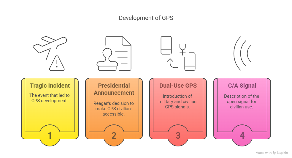
In 1983, a tragic mistake changed everything. Korean Air Lines Flight 007 strayed into Soviet airspace and was shot down, killing all 269 passengers. Investigations revealed that a navigational error caused the deviation and that GPS could have prevented it.
In response, President Ronald Reagan announced that the U.S. would make GPS available for civilian use, with access to lower-accuracy signals to protect national security. This marked the birth of dual-use GPS: one encrypted stream for military use, another open stream (with reduced precision) for the world.
The open signal, known as Coarse/Acquisition (C/A), was added to the first operational GPS satellites (Block IIA) in the early 1990s.
The Consumer Boom: After Selective Availability Was Disabled
Even with civilian access, the full precision of GPS wasn’t available to the public until May 1, 2000, when President Bill Clinton ordered Selective Availability to be turned off. Overnight, the accuracy of civilian GPS improved tenfold, from about 100 meters down to 10 meters.
This single policy decision kicked off an explosion of consumer innovation. Companies that had been building rugged GPS systems for surveyors, mariners, and aviators suddenly found mainstream demand.
The Companies That Made GPS Practical
Here’s how GPS entered the consumer market:
- Trimble Navigation: Founded in 1978, it was among the first to develop commercial GPS receivers for surveying, mapping, and agriculture. Trimble’s early products were heavy and expensive but accurate.
- Magellan Systems Corporation: Launched the Magellan NAV 1000 in 1989, the world’s first handheld GPS device.
- Garmin: Founded in 1989, Garmin released its first portable GPS unit in 1991. The company’s aviation, marine, and automotive products helped normalize GPS for professional and recreational use.
- Motorola, Qualcomm, and Texas Instruments: These tech giants worked on embedding GPS into chipsets and modems, laying the groundwork for mobile phones with built-in location services.
By the mid-2000s, GPS was being bundled into everything: cars, phones, watches, pet collars, autonomous vehicles – even farming tractors with auto-guided steering.
The Smartphone Revolution and A-GPS
GPS went mainstream when it went mobile.
The launch of the iPhone in 2007 and the Android ecosystem soon after made GPS a built-in feature for navigation, location-based apps, geo-tagging, and more. But phones had a challenge: small antennas and limited power.
To fix that, carriers implemented Assisted GPS (A-GPS), which used cell tower data to help mobile devices lock onto satellites faster. A-GPS significantly improved speed and performance in urban environments.
Companies like Qualcomm played a huge role here, incorporating A-GPS support into their Snapdragon processors, which powered a large chunk of the mobile market.
From Exclusive Tech to Invisible Infrastructure
Today, GPS feels like magic. But the experience we take for granted, fast, accurate, continuous location data, was built through decades of:
- Policy evolution (Reagan and Clinton opening access)
- Hardware miniaturization (from backpack receivers to microchips)
- Network expansion (31+ satellites in orbit today) and
- Private sector ingenuity (from Magellan to Apple and Google).
And while we casually use it to find tacos or track a run, GPS now powers:
- Aviation and maritime navigation
- Precision agriculture
- Disaster response and search-and-rescue
- Fleet management and logistics
- Financial market timestamping
- Scientific research (e.g., tectonic plate movement)
This isn’t just a tech product. It’s a planet-scale utility.
The Patents That Made GPS Possible
The Global Positioning System transformed navigation by enabling precise real-time location tracking from virtually anywhere on Earth. But before GPS became ubiquitous in cars, smartphones, and logistics systems, it was built on decades of satellite tracking, signal processing, and geolocation innovation.
To trace this evolution, we used the Global Patent Search tool, which semantically matches plain-English technology descriptions to historically relevant patents across global databases.
We entered the query: “Satellite-based system that provides real-time location and navigation data” and analyzed filings between 1955 and 1990 to uncover early innovations that enabled the rise of global satellite navigation.

Source: Global Patent Search
We chose this range as it captured the invention window that begins with Cold War-era satellite experiments and ends just before the first commercial handheld GPS receivers entered the market. Between 1955 and 1990, key patents were filed that formalized passive ranging, Doppler tracking, terrain-aware navigation, and map-matching. These were all foundational to how GPS works today.
Here’s what we discovered: Between 1983 and 1990, foundational patents emerged that introduced techniques such as Doppler-based location tracking, terrain map integration, autonomous vehicle navigation, and satellite signal correction.
These breakthroughs formed the core building blocks of GPS as we know it. Below is a chronological list of 15 foundational patents from that period and why each was pivotal.
| Priority Date | Patent Title | Patent Number | Why It’s Foundational |
| 1983-12-22 | Data Collecting System | JPS59115643A | Demonstrated how mobile satellite data platforms could collect and transmit position/location data from remote sensors, influencing environmental and remote monitoring. |
| 1984-07-20 | Satellite Navigation System for Determining Marks Over Time | FR2568017A1 | Early use of time-coded satellite signals for determining position using revolving satellites, a core GPS concept. |
| 1984-08-16 | Position Determination and Message Transfer System | CA1272519A | Introduced dual-satellite timing triangulation enhanced with terrain elevation maps, improving surface-level location accuracy. |
| 1984-09-28 | Radio Navigation System | GB2166617A | Hybrid system combining satellite and terrestrial signals to compute real-time location, showing transition from terrestrial nav systems to space-based GPS. |
| 1985-09-20 | System for Positioning and Transmitting Messages Using Satellites and Stored Topographic Maps | CN1007293B | Used topographic maps to refine GPS position fixes, important for civilian applications where terrain distorted standard GPS readings. |
| 1986-01-31 | Apparatus for Monitoring Physiological Parameters | WO8604497A1 | Though health-focused, it used Doppler and movement tracking tied to GPS for mobile position-based fitness systems; prefiguring wearables with GPS. |
| 1986-10-13 | Position Measuring Method Using a Satellite | US4924699A | Showed use of road map data to correct GPS errors; a precursor to map-matching used in today’s automotive GPS. |
| 1987-03-26 | Automotive Navigation System | US4912645A | First commercial example of vehicle-based GPS receivers integrated with in-car displays, enabling turn-by-turn navigation. |
| 1987-09-28 | Navigation Assisting System Utilizing Artificial Satellite | JPS6484172A | Introduced two-way communication between vehicles and satellites for map updates and real-time location; an early connected car concept. |
| 1987-10-21 | On-Vehicle Navigator | JPH01109278A | Integrated GPS position tracking with path prediction to improve real-time vehicle tracking accuracy under limited satellite visibility. |
| 1988-03-31 | Vehicle Navigation Method | JPH01250817A | Developed fallback mechanisms using dead reckoning when GPS signal was poor; used in today’s inertial navigation systems. |
| 1988-08-12 | Method for Determining Instantaneous Location of a Mobile Radio Station | DE3827352A1 | Merged mobile radio and GPS for user-controlled position broadcasting; relevant to location privacy and telecom-GPS integrations. |
| 1989-03-16 | Method of Removing Virtual Oscillation Source of Data Gathering Device | JPH02243984A | Enhanced satellite-based Doppler positioning by filtering signal oscillation; improving signal stability and accuracy. |
| 1989-10-02 | Telemetry, Tracking and Control for Satellite Cellular Communication Systems | CA2023611C | Embedded GPS in satellites themselves, allowing real-time satellite position data to enhance accuracy; pivotal in satellite constellation calibration. |
| 1990-07-19 | Cellular Communication System by Satellite with Assisted Subscriber Unit | ES2063449T3 | Demonstrated user-side GPS position self-detection with satellite relaying; closely resembling Assisted GPS (A-GPS) used in smartphones. |
These patents represent key milestones in the evolution of GPS technology, each contributing uniquely to the system’s accuracy, reliability, and diverse applications across various sectors.
The Overlooked Inventors and the IP Fights That Followed
Roger L. Easton and the Quest for Recognition
Roger L. Easton, a pivotal figure in the development of GPS, was instrumental in creating the Timation satellite system, which laid the groundwork for modern GPS by combining precise timekeeping with satellite technology.
He secured several patents, including US3789409, titled “Navigation System Using Satellites and Passive Ranging Techniques,” granted on January 29, 1974.
Despite his significant contributions, Easton’s role was not widely recognized for many years. It wasn’t until later in his life that he received accolades, such as the National Medal of Technology in 2006 and induction into the National Inventors Hall of Fame in 2010. While there is no public record of Easton or his family engaging in legal battles for recognition or royalties, the delayed acknowledgment highlights the challenges inventors can face in securing credit for their innovations.
Trimble Navigation vs. Competitors: Protecting GPS Innovations
Trimble Navigation, founded in 1978, emerged as a leader in commercial GPS technology. The company has been proactive in defending its intellectual property. In November 1994, Trimble initiated legal action against a competitor, alleging infringement of its “Narrow Correlator” patent.
The competitor responded in March 1995 with a countersuit, claiming Trimble infringed on its patent. These lawsuits were part of a broader pattern of IP litigation as companies vied for dominance in the burgeoning GPS market.
Additionally, Trimble faced a securities class action lawsuit filed on December 6, 1995, which was settled with a payment of $1.8 million, funded by insurance proceeds. This case underscores the multifaceted legal challenges technology companies can encounter, extending beyond patent disputes.
Legal disputes have influenced not only the trajectory of technological advancements but also the strategies companies employ to protect and monetize their innovations.
Understanding these IP battles provides insight into the challenges and dynamics that shape the technologies we rely on daily.
Licensing and IP Complexity in GPS Technology
The Global Positioning System (GPS) began as a U.S. military project. Today, it powers nearly every modern device and service that depends on location data. And while the core signals from the GPS satellite constellation are free to use, the technologies layered on top, like high-accuracy positioning, indoor navigation, and device integration, are not.
There’s no centralized licensing authority or patent pool managing GPS-related intellectual property. Instead, the ecosystem is defined by fragmented ownership, proprietary enhancements, and a growing number of cross-licensing agreements.
IP Complexity: What’s Protected and What Isn’t?
The GPS signal itself, maintained by the U.S. Space Force, is globally available and unencumbered by licensing fees. But once you move into:
- Assisted GPS (A-GPS)
- High-accuracy positioning systems (e.g., RTK, PPP)
- Urban and indoor location technologies
- Receiver chip designs and signal filtering techniques.
You’re in the world of proprietary patents. Companies like Qualcomm, Broadcom, u-blox, Trimble, and Locata hold thousands of patents that power these capabilities. Most of these are not standardized and must be licensed on a case-by-case basis.
Cross-Licensing: The Silent Backbone of GPS Innovation
Because no universal framework exists, many companies rely on cross-licensing to avoid litigation and share innovations. In this model, two or more parties grant each other rights to use specific patents, sometimes royalty-free, sometimes with conditions. It’s common in GPS chipsets, where multiple patents are required to build a viable commercial receiver.
Cross-licensing keeps innovation moving but also creates opacity. Without a public database or SEP designation, it’s hard for developers and startups to know what IP they might infringe on.
Regulatory Attention: Governments are Taking Notice
The European Commission has flagged GNSS-related patents as an area of growing importance. As the EU continues investing in its system (Galileo), there’s concern about fragmented patent ownership, licensing opacity, and future litigation risk.
Recent EU proposals include:
- Creating databases of SEP holders for critical technologies
- Requiring mandatory arbitration before litigation
- Promoting transparency in licensing terms
These regulations aren’t GPS-specific yet, but they reflect a wider trend: as location tech becomes essential infrastructure, governments want more oversight.
What does this mean for Builders and Innovators?
If you’re building with GPS, whether it’s fleet tracking, drone navigation, wearable tech, or location-based ads, you’re likely interacting with patented systems and algorithms.
- Don’t assume GPS is “public domain”.
- Know which layers of the tech stack are open and which are proprietary.
- Consider Patent search tools like Global Patent Search.
In the absence of formal licensing bodies, the responsibility falls on innovators to map the patent terrain, validate their ideas, and build with confidence.
How Global Patent Search Helps You Navigate GPS-Related Innovation?

Working on a GPS-related innovation or exploring existing patents in navigation tech?
Global Patent Search helps you:
- Find prior art using natural language; no patent codes required.
- Identify GPS-related inventions filed before or after key breakthroughs.
- Understand which patents are closest to your idea.
- Explore global filings to avoid regional blind spots.
If you’re building in location, mobility, or navigation tech, the Global Patent Search tool, can help surface relevant patents faster to move forward with clarity. Try it now!